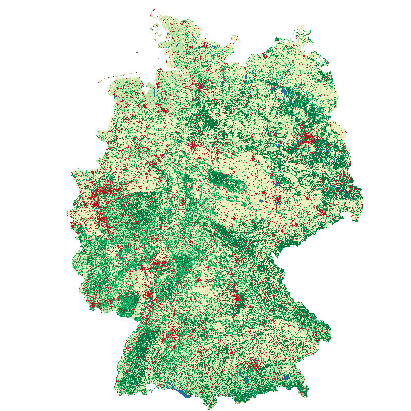
| This land cover classfication of Germany was created using Sentinel-2 imagery from the years 2015 to 2017 and LUCAS 2015 in-situ reference data (https://ec.europa.eu/eurostat/web/lucas). It contains seven land cover types: (1) artificial land, (2) open soil, (3) high seasonal vegetation, (4) high perennial vegetation, (5) low seasonal vegetation, (6) low perennial vegetation and (7) water with a spatial resolution of 10m x 10m. For further information, please see the following publication: https://doi.org/10.1016/j.jag.2020.102065 | ||
 |
||
| Suggested Data Citation | ||
| German Aerospace Center (DLR) (2020): Land Cover DE - Sentinel-2 - Germany, 2015. https://doi.org/10.15489/1ccmlap3mn39 | ||
| Coverage | ||
| Yellow dots or areas indicate coverage range. | ||
| Geographic Boundaries | ||
| North: | 55.15° | |
| West: | 5.55° | |
| East: | 16.43° | |
| South: | 47.15° | |
| Time Period | ||
| Start date: | 2015-06-27 | |
| End date: | 2017-09-29 | |
| More Information | ||
| Keywords: | Land cover, Sentinel-2, Land cover map, Germany, opendata | |
| Contact: | geoservice@dlr.de | |
| Access / Use Restriction: | License | |
| Data Use Guidelines | Creative Commons BY-NC 4.0 | |
| Links | ||
| Mission / Project Information | ||
| Reference | https://doi.org/10.1016/j.jag.2020.102065 Weigand, M., Staab, J., Wurm, M., Taubenböck, H. (2020): Spatial and semantic effects of LUCAS samples on fully automated land use/land cover classification in high-resolution Sentinel-2 data, International Journal of Applied Earth Observation and Geoinformation, Volume 88, 102065, ISSN 0303-2434. |
|
| DOI (of Dataset) | https://doi.org/10.15489/1ccmlap3mn39 Digital Object Identifier |
|
| Downloading Data | ||
| HTTP Download (Land Cover DE) | https://download.geoservice.dlr.de/LCC_DE/files/ HTTP Download |
|
| Data Visualization Service | ||
| Land Cover DE, 2015 | https://geoservice.dlr.de/eoc/land/wms? LCC_DE_2015 |
|
| EOC Geoservice Map Context (de:lcc) | https://geoservice.dlr.de/web/maps/de:lcc EOC Geoservice Map Context |
|