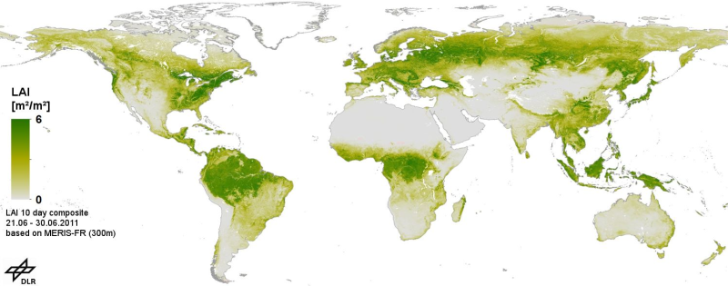
| This product consists of global gap free Leaf area index (LAI) time series, based on MERIS full resolution Level 1B data. It is produced as a series of 10-day composites in geographic projection at 300m spatial resolution. The processing chain comprises geometric correction, radiometric correction and pixel identification, LAI calculation with the BEAM MERIS vegetation processor, re-projection to a global grid, and temporal aggregation selecting the measurement closest to the mean value. After the LAI pre-processing we applied time series analysis to fill data gaps and filter outliers using the technique of harmonic analysis in combination with mean annual and multiannual phenological data. Data gaps are caused by clouds, sensor limitations due to the solar zenith angle (less than 10 degrees), topography and intermittent data reception. We applied our technique for the whole period of observation. Validation was performed using VALERI and BigFoot data. | ||
 |
||
| Suggested Data Citation | ||
| German Aerospace Center (DLR) (2015): MERIS - Gap Free Leaf Area Index (LAI) - Global. https://doi.org/10.15489/ak90g1wty909 | ||
| Coverage | ||
| Yellow dots or areas indicate coverage range. | ||
| Geographic Boundaries | ||
| North: | 90° | |
| West: | -180° | |
| East: | 180° | |
| South: | -60° | |
| Time Period | ||
| Start date: | 2003-01-01 | |
| End date: | 2011-01-31 | |
| More Information | ||
| Keywords: | Land cover, MERIS, LAI, ENVISAT, Time series analysis | |
| Contact: | Helpdesk-DFD@dlr.de | |
| Access / Use Restriction: | copyright | |
| Data Use Guidelines | https://geoservice.dlr.de/resources/licenses/D-SDA_DataLicenseTerms.pdf | |
| Links | ||
| DOI: | https://doi.org/10.15489/ak90g1wty909 Digital Object Identifier |
|
| Ordering Data | ||
| EOWEB GeoPortal |
https://geoservice.dlr.de/egp/main?ecswCollection=urn%3Aeop%3ADLR%3AEOWEB%3AMERIS-FR-LAI-HA MERIS-LAI |
|