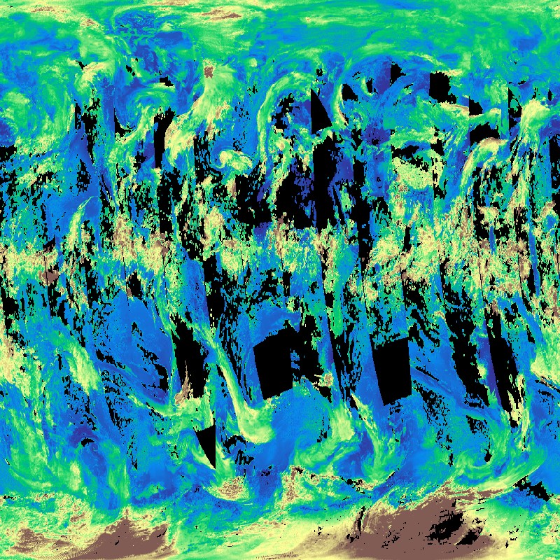
| The TROPOMI instrument onboard the Copernicus SENTINEL-5 Precursor satellite is a nadir-viewing, imaging spectrometer that provides global measurements of atmospheric properties and constituents on a daily basis. It is contributing to monitoring air quality and climate, providing critical information to services and decision makers. The instrument uses passive remote sensing techniques by measuring the top of atmosphere solar radiation reflected by and radiated from the earth and its atmosphere. The four spectrometers of TROPOMI cover the ultraviolet (UV), visible (VIS), Near Infra-Red (NIR) and Short Wavelength Infra-Red (SWIR) domains of the electromagnetic spectrum. The operational trace gas products generated at DLR on behave ESA are: Ozone (O3), Nitrogen Dioxide (NO2), Sulfur Dioxide (SO2), Formaldehyde (HCHO), Carbon Monoxide (CO) and Methane (CH4), together with clouds and aerosol properties. Daily observations are binned onto a regular latitude-longitude grid. This product displays the Cloud-Top Height (CTH) around the globe. Clouds play a crucial role in the Earth's climate system and have significant effects on trace gas retrievals. The cloud-top height is retrieved from the O2-A band using the ROCINN algorithm. The DLR INPULS project develops (a) innovative retrieval algorithms and processors for the generation of value-added products from the atmospheric Copernicus missions Sentinel-5 Precursor, Sentinel-4, and Sentinel-5, (b) cloud-based (re)processing systems, (c) improved data discovery and access technologies as well as server-side analytics for the users, and (d) data visualization services. | ||
 |
||
| Suggested Data Citation | ||
| Data: Sentinel-5P Tropomi L3 data ©DLR [year of acquisition] All rights reserved. Contains modified Copernicus Sentinel data, processed by DLR, licensed under CC-BY 4.0. https://doi.org/10.15489/ozxr4ngp0473 | ||
| Coverage | ||
| Yellow dots or areas indicate coverage range. | ||
| Geographic Boundaries | ||
| North: | 90.00° | |
| West: | 180.00° | |
| East: | 180.00° | |
| South: | 90.00° | |
| Time Period | ||
| Start date: | 2018-04-30 | |
| End date: | Present | |
| More Information | ||
| Keywords: | DLR, EOC, Sentinel-5P, TROPOMI, Atmosphere, Cloud-Top Height (CTH), Daily, Level 3, opendata | |
| Contact: | Victor.MolinaGarcia@dlr.de | |
| Access / Use Restriction: | License | |
| Data Use Guidelines | Creative Commons BY 4.0 | |
| Links | ||
| Mission / Project Information | ||
| Atmos - TROPOMI / S5P Webpage (html) | https://atmos.eoc.dlr.de/app/missions/tropomi Project Website |
|
| Atmos - TROPOMI / S5P Webpage Calendar (html) | https://atmos.eoc.dlr.de/app/calendar Project Website Quicklook Calendar |
|
| DOI: | https://doi.org/10.15489/ozxr4ngp0473 Digital Object Identifier |
|
| Product Search / Ordering | ||
| Product Catalogue (STAC): S5P Tropomi L3 P1D CTH | https://geoservice.dlr.de/eoc/ogc/stac/v1/collections/S5P_TROPOMI_L3_P1D_CTH S5P Tropomi L3 P1D CTH Products |
|
| Downloading Data | ||
| HTTP download (Sentinel-5p Tropomi L3) | https://download.geoservice.dlr.de/S5P_TROPOMI/files/L3/ HTTP download |
|
| Data Visualization Service | ||
| EOC Geoservice Map Context (s5p:tropomi:l3) | https://geoservice.dlr.de/web/maps/s5p:tropomi:l3 EOC Geoservice Map Context |
|
| WMS access: S5P L3 Cloud-Top Height (CTH) | https://geoservice.dlr.de/eoc/atmosphere/wms? S5P_TROPOMI_L3_P1D_CTH |
|