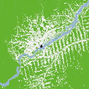
TanDEM-X Forest/Non-Forest Map - Global items
Properties:
- Name: TDM_FNF_50
- Title: TanDEM-X Forest/Non-Forest Map - Global
- Description: The TanDEM-X Forest/Non-Forest Map is a project developed by the Microwaves and Radar Institute at the German Aerospace Center (DLR), within the activities of the TanDEM-X mission. The goal is the derivation of a global forest/non-forest classification mosaic from TanDEM-X bistatic interferometric synthetic aperture radar (InSAR) data, acquired for the generation of the global digital elevation model (DEM) in Stripmap single polarization (HH) mode.
- License: proprietary
- Platform: TanDEM-X / TerraSAR-X
- Platform Serial Identifier: TDX-1 / TSX-1
- Instrument: InSAR
- Sensor Type: RADAR
- Security constraints: No
Extents:
- Spatial: -180, -90, 180, 90
- Temporal: 2011-01-01T00:00:00Z / 2015-12-31T00:00:00Z
Keywords:
-
DLR
EOC
Land
HR
TanDEM-X
TerraSAR-X
TSX-1
TDX-1
InSAR
Forest Map
Global Forest Map
TanDEM-X Global Forest
