Skip navigation

Introduction

TanDEM-X (TerraSAR-X add-on for Digital Elevation Measurements) is an Earth observation radar mission that consists of a SAR interferometer built by two almost identical satellites flying in close formation. They have been acquiring data for the generation of the global Digital Elevation Model (DEM) between 2011 and 2015 in stripmap single polarization (HH) mode. For more information on the TanDEM-X mission, please visit the TanDEM-X project page.

The global dataset of quicklook images, representing a spatially averaged version of the original full resolution data at a ground independent pixel spacing of 50 m x 50 m, has been used for the generation of the TanDEM-X Forest/Non-Forest (FNF) Map. The TanDEM-X FNF Map offered here for download has therefore a pixel spacing of 1.6 arcseconds (arsec), which corresponds to approximately 50m at the equator.

This information page gives an overview about the basic product specifications of the TanDEM-X FNF Map and explains how to download the TanDEM-X 50m FNF data sets. The license terms for the use of the data is automatically accepted by downloading the data. At the end of this page, suggestions for further readings and literature, a FAQ, tips for software tools, and contact information can be found.


Overview of the TanDEM-X FNF Product Description

The following chapter gives a short overview about the essential products specifications of the TanDEM-X FNF Map. The TanDEM-X 50m FNF Map offered for download follows in the most aspects this specification. DLR recommends for in-depth reading the download of the latest TanDEM-X FNF Map specification document, which can be found here: TanDEM-X FNF Map Product Description.

Product File Structure

The TanDEM-X 50m FNF Map is delivered in a compressed ZIP (*zip) format. Each zip file contains a main folder and 2 subfolders. In the main folder there are:

  1. The FNF Map quicklook raster file
  2. The license agreement - english version
  3. The license agreement - german version

In the subfolders there are:

  1. FNF: The FNF Map raster layer
  2. AUXFILES: The following information files:
      1. Coverage map
      2. Super pixels date map
      3. Super pixels count map
      4. Acquisition information text file

The FNF Map as well as the different information layers are in an 8-bit GeoTIFF (*.tif) raster format, which can be automatically upload on Google Earth Pro for inspection. All FNF Map products between 0° - 60° North/South latitude have a file extent of 1° x 1° in latitude and longitude direction, respectively. The corresponding pixel spacing is 1.6” x 1.6”.

Raster Values of the FNF Map Layer

The raster values in the FNF Map GeoTIFF file are:

    0: invalid pixels and settlements
    1: forested areas
    2: non-forested areas
    3: water bodies

For further details on the raster values for the auxiliary information layers, see the TanDEM-X FNF Map Product Description.


Access to the TanDEM-X 50m FNF Map Data Sets

To get access to the products, you accept the user license, which can be found as PDF document here:

User License

English Version: License agreement regarding the use of the TanDEM-X Forest/Non-Forest Map data product
German Version: Lizenzvereinbarung über die Nutzung des Datenprodukts TanDEM-X Forest/Non-Forest Karte

Downloading Products

For the downloading of TanDEM-X 50m FNF products three options (either via HTTPS or FTPES), are available, depending on your preferences, your machine, your system settings and the amount of data you want to download. Solely encrypted connections are supported; plain HTTP or FTP download methods are not supported.

  1. Option A: HTTPS Web browser & map-based interface for selecting individual tiles.
  2. Option B: HTTPS Web browser interface for selecting individual tiles directly by browsing the directory structure


Option A – Using a HTTPS Web browser & map-based interface

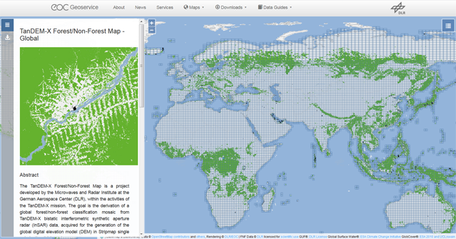
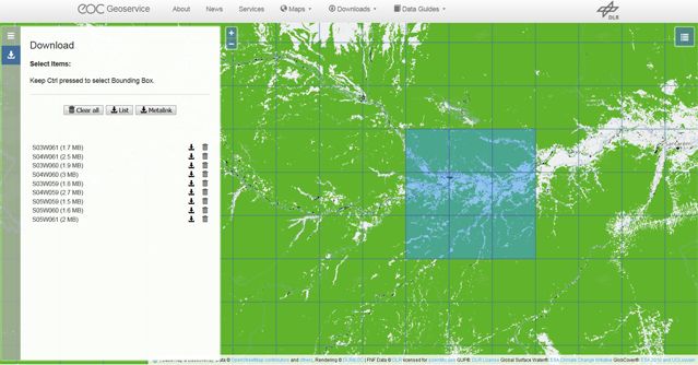
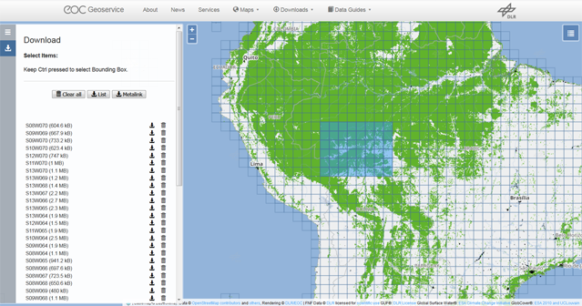
This download option is recommended for users who wish to download a few products and who prefer the usage of a map driven interface for the selection of the products.

  1. Enter the URL of the map interface in a new web browser tab:
    https://download.geoservice.dlr.de/FNF50


    Geoservice Start Page after login

    The page will appear with basic information about the TanDEM-X mission on the left and the map interface (showing a color coded version of the TanDEM-X global Forest/Non-Forest Map) with the polygon outline for each individual tile on the right. You can alter the map layer(s) shown in the map with the icon in the top right corner above the map canvas. Zoom to your region of interest, if needed.

  2. Select the desired products (=left-click with the mouse on the corresponding tile). The name of the product appears in a list on the left side.

    Geoservice FNF Map Tile selected

    Alternatively you can also draw a search rectangle in order to download the products for a larger region of interest. Press the CTLR key on your keyboard while left-clicking with the mouse on a point and drag and draw the rectangle on the map. The search rectangle will be closed and the products will be selected, when you release the mouse button. Selected products appear on the left side of the page. You can remove single items from the list by selecting the trash bin icon associated which each item.

    Geoservice FNF Map Tiles selected by rectangle

  3. After the desired products have been selected, they can be saved on your computer file by file by clicking on the download icon associated to each item.

  4. Optional: If you want to automate the download of a larger list of files you can select the ‘List’ icon to save the download list to an ASCII text file (with an absolute pathname for each file per line), or you can select the metalink icon to save the file list to an XML-like metalink file.

    Geoservice save file list

    The ASCII file list can then be fed to a command line FTP client (e.g. wget or cURL, which are included in numerous Linux distributions), or to a download manager (e.g. aria2). The following code examples will illustrate the usage of those command line tools. The final line of code might need some adaptions with respect to individual system settings (e.g. whether a proxy is needed), but might serve as a starting point.

    Suppose you have saved the list to the name ‘TDM50mFNF-url-list.txt’ to your current working directory and the download directory will be the current working directory as well, then the wget command would be the following one-liner:
    wget -i TDM50mFNF-url-list.txt --auth-no-challenge

    The cURL command line would be:
    curl $(printf ' -O %s' $(<TDM50mFNF-url-list.txt))

    or, alternatively
    xargs -a TDM50mFNF-url-list.txt -L1 curl -O

    The aria2 command line would be:
    aria2c -i TDM50mFNF-url-list.txt

    The metalink XML file can be fed to a download manager tool (e.g. aria2). Suppose you have saved the metalink to the file name ‘TDM50FNF.meta4’ in your current working directory, then the command line for aria2 would be:
    aria2c -M TDM50FNF.meta4


Option B: Using a HTTPS Web browser and browsing the directories

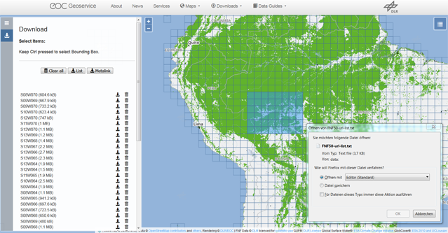
The files can be also accessed via HTTPS by entering the following URL path into your web browser: https://download.geoservice.dlr.de/FNF50/files/. Single files can be downloaded by clicking on the files.


Directory Structure on the FTP Server:

The main directory structure on the FTP server contains just a FNF main directory. In this directory all available TanDEM-X 50m FNF products including the FNF Map and the auxiliary files are stored in a compressed ZIP (*.zip) format. Go here, if you need the complete data set for a certain FNF tile.

The main directory FNF is organized in a hierarchical directory structure and it contains subdirectories. The first subdirectory level is based on latitudes, one separate directory for each latitude value; each latitude subdirectory is subdivided into further subdirectories for the longitude spaced by 10 degree. Only subdirectories actually containing FNF tiles are visible.

Example: the directory ‘/FNF50/files/N49/E010’ contains the following 10 zip files:

      TDM_FNF_20_N49E010.zip
      TDM_FNF_20_N49E011.zip
      TDM_FNF_20_N49E012.zip
      TDM_FNF_20_N49E013.zip
      TDM_FNF_20_N49E014.zip
      TDM_FNF_20_N49E015.zip
      TDM_FNF_20_N49E016.zip
      TDM_FNF_20_N49E017.zip
      TDM_FNF_20_N49E018.zip
      TDM_FNF_20_N49E019.zip


Frequently Asked Questions

Coming Soon...


Further Reading: Literature/Weblinks

Citation of the two listed papers [R01] and [R03] is adequate if you use the TanDEM-X FNF Map.

Literature

[R01] Martone, M., Rizzoli, R., Wecklich, C., González, C., Bueso-Bello, J.L., Valdo, P., Schulze, D., Zink, M., Krieger, G., Moreira, A., 2018. The Global Forest/Non-Forest Map from TanDEM-X Interferometric SAR Data. Remote Sensing of Environment, vol. 205, pp. 352-373.

[R02] Martone, M., Sica, F., González, C., Bueso-Bello, J.L., Valdo, P., Rizzoli, P., 2018. High-Resolution Forest Mapping from TanDEM-X Interferometric Data Exploiting Nonlocal Filtering. Remote Sens., 10, 1477.

[R03] Esch, T., Heldens, W., Hirner, A., Keil, M., Marconcini, M., Roth, A., Zeidler, J., Dech, S., Strano, E., 2017. Breaking new ground in mapping human settlements from space - the global urban footprint, ISPRS Journal of Photogrammetry and Remote Sensing, no. 134, pp. 30-42.

[R04] Krieger, G., Zink, M., Bachmann, M., Bräutigam, B., Schulze, D., Martone, M., Rizzoli, P., Steinbrecher, U., Antony, J.W., De Zan, F., Hajnsek, I., Papathanassiou, K., Kugler, F., Rodriguez Cassola, M., Younis, M., Baumgartner, S., López-Dekker, P., Prats, P., Moreira, A., 2013. TanDEM-X: a radar interferometer with two formation-flying satellites. Acta Astronaut. 89, 83-98.

[R05] Rizzoli, P., Martone, M., Gonzalez, C., Wecklich, C., Borla Tridon, D., Bräutigam, B., Bachmann, M., Schulze, D., Fritz, T., Huber, M., Wessel, B., Krieger, G., Zink, M., and Moreira, A. (2017): Generation and performance assessment of the global TanDEM-X digital elevation model. ISPRS Journal of Photogrammetry and Remote Sensing, Vol 132, pp. 119-139.

[R06] Martone, M., Bräutigam, B., Rizzoli, P., Gonzalez, C., Bachmann, M., Krieger, G., 2012. Coherence evaluation of TanDEM-X interferometric data. ISPRS J. Photogramm. Remote Sens. 73, 21–29.

Weblinks

For more information on the TanDEM-X mission, please visit:
TanDEM-X Forest/Non-Forest Map project page

TanDEM-X 90m DEM download page:
https://download.geoservice.dlr.de/TDM90/

Further information on TanDEM-X science activities and proposal web forms for DEM products at 12m and 30m spatial resolution:
https://tandemx-science.dlr.de


License: Terms of Use

Every user intending to download TanDEM-X 50m FNF products accepts automatically the user license. The license is exclusively granted for non-commercial and scientific utilization of the TanDEM-X 50m FNF data set provided by DLR. You can find the PDF document here:

User Licence for the Utilization of the TanDEM-X 50m FNF Map Data Products for Scientific Use

Or you can read the original text here:

License agreement regarding the use of the TanDEM-X Forest/Non-Forest Map data product

Hereby a license for the use of TanDEM-X Forest/Non-Forest (FNF) Map, as defined below, is made available for the public free of charge, but only for non-commercial and scientific purposes. A license for commercial use of TanDEM-X Forest/Non-Forest Map is not included therewith. A license for commercial use of TanDEM-X Forest/Non-Forest Map is to be purchased separately by the German Aerospace Center.

License terms and rights of use:
  1. Definitions

    1. The TanDEM-X Forest/Non-Forest Map product was derived from the global TanDEM-X data base and has a pixel spacing of 50 m. The TanDEM-X Forest/Non-Forest Map product contains all data provided on the DLR delivery server, including all supplemental data and metadata.

    2. The German Aerospace Center (DLR) is the author and owner of the TanDEM-X Forest/Non-Forest Map.
      Deutsches Zentrum für Luft- und Raumfahrt e.V.
      German Aerospace Center (DLR)
      Linder Höhe
      51147 Köln
      Germany

    3. Commercial use is marketing, especially the sale of TanDEM-X Forest/Non-Forest Map product or products generated or derived from the TanDEM-X Forest/Non-Forest Map product for the purpose of receiving a fee/remuneration. Each use of TanDEM-X Forest/Non-Forest Map product or products generated or derived from the TanDEM-X Forest/Non-Forest Map product is deemed to be a commercial use as far as the use is not free of charge.

    4. Scientific use is the use of TanDEM-X Forest/Non-Forest Map product or products generated or derived from the TanDEM-X Forest/Non-Forest Map product by public or private research organisations or researchers (i.e. universities, research institutes, governmental research organisations) for the purpose to gain academic research results and to present the results free of charge to the public.

    5. Non-commercial use means any use of the TanDEM-X Forest/Non-Forest Map product or products generated or derived from the TanDEM-X Forest/Non-Forest Map product, that is not commercial use and not scientific use. Each non-commercial use of TanDEM-X Forest/Non-Forest Map product or products generated or derived by TanDEM-X Forest/Non-Forest Map product has to be free of charge.

    6. The following licenses used to create the TanDEM-X Forest/Non-Forest Map must be quoted by the licensee:

        1. Global Urban Footprint by DLR:
          https://www.dlr.de/eoc/desktopdefault.aspx/tabid-11725/20508_read-47944/

        2. Global Surface Water by ESA:
          https://maps.elie.ucl.ac.be/CCI/viewer/download.php
        3. The present products are made available to the public by ESA and the consortium. You may use one or several CCI-LC products land cover map for educational and/or scientific purposes, without any fee on the condition that you credit the ESA Climate Change Initiative and in particular its Land Cover project as the source of the CCI-LC database:
          Copyright notice: © ESA Climate Change Initiative - Land Cover led by UCLouvain (2017)

          Should you write any scientific publication on the results of research activities that use one or several CCI-LC products as input, you shall acknowledge the ESA CCI Land Cover project in the text of the publication and provide the project with an electronic copy of the publication (contact@esa-landcover-cci.org).

          If you wish to use one or several CCI-LC products in advertising or in any commercial promotion, you shall acknowledge the ESA CCI Land Cover project and you must submit the layout to the project for approval beforehand (contact@esa-landcover-cci.org).

        4. GlobCover by ESA:
          The GlobCover products have been processed by ESA and by the Université Catholique de Louvain. They are made available to the public by ESA. You may use the GlobCover land cover map for educational and/or scientific purposes, without any fee on the condition that you credit ESA and the Université Catholique de Louvain as the source of the GlobCover products:
          Copyright notice: © ESA 2010 and UCLouvain

          Accompanied by a link to the ESA DUE GlobCover website:
          http://due.esrin.esa.int/page_globcover.php

  2. A non-exclusive, spatially and temporally unlimited, non-transferable, non-sublicensable right to use the TanDEM-X Forest/Non-Forest Map product is granted free of charge for scientific purposes and non-commercial purposes.
    This license does not grant any commercial use of TanDEM-X Forest/Non-Forest Map product or products generated or derived from the TanDEM-X Forest/Non-Forest Map product.
    The TanDEM-X Forest/Non-Forest Map may not be passed on to third parties or published.

  3. The transfer of the TanDEM-X Forest/Non-Forest Map to third parties as well as its publication is forbidden. In case of cooperation of the Licensee with a third party and planned use of the original data by this cooperation partner, the Licensee undertakes to expressly inform his cooperation partner about the license for the use of the TanDEM-X Forest/Non-Forest Map data and to make it available to him. The Licensee commits himself to grant any kind of access to the provided TanDEM-X Forest/Non-Forest Map product only to its own employees.

  4. In the event of any unauthorised use of the TanDEM-X Forest/Non-Forest Map product or products generated or derived from the TanDEM-X Forest/Non-Forest Map, the license is deemed not to have been given.

  5. In publications based on the TanDEM-X Forest/Non-Forest Map the Licensee undertakes to clearly mark all data in such a way that the authorship and copyright of DLR is comprehensible to all:

    “© DLR

    and to cite the following reference paper:

    “Martone, M.; Rizzoli, P.; Wecklich C.; González, C.; Bueso-Bello, J.L.; Valdo, P.; Schulze, D.; Zink, M.; Krieger, G.; Moreira, A. The Global Forest/Non-Forest map from TanDEM-X Interferometric SAR Data. Remote Sensing of Environment 2018, 205, 352–373”.

    Derived information must include a reference to the TanDEM-X Forest/Non-Forest Map as data source, regardless of the form in which it was created.
Liability / Warranty:
  1. TanDEM-X Forest/Non-Forest Map product is provided without any warranty.

  2. The Licensee assumes full responsibility for the contractual use of the TanDEM-X Forest/Non-Forest Map.

  3. The Licensee is liable to DLR for all damages, regardless of the legal reasons, caused through intent or negligence.

  4. DLR may not be obliged to third parties by this Agreement. DLR only accepts liability for damages in the case of intentional or grossly negligent conduct. DLR’s liability for negligence is limited to the foreseeable damage typically occurring with contracts of that kind. Liability for further damages is excluded. The Licensee indemnifies DLR in full against any claims by damaged third parties.
Termination
  1. DLR reserves the right to terminate the provision of the TanDEM-X Forest/Non-Forest Map to the Licensee and/ or the license to use the TanDEM-X Forest/Non-Forest Map at any time. The Licensee has the right to terminate the license at any time.

  2. In the event of termination of the license, the Licensee is obligated to delete the TanDEM-X Forest/Non-Forest Map and all its copies and to confirm this in writing to DLR upon request.

  3. The Licensee has no right to compensation or damages as a result of termination.
Miscellaneous

Changes or additions to this license agreement are only effective if agreed in writing by both parties. This license is subject to the laws of the Federal Republic of Germany, to the exclusion of the United Nations Convention on Contracts for the International Sale of Goods.


Contact

The EOC Geoservice Team

    For technical problems, e.g. with the FTP download, or with the download via map interface etc., please contact the EOC Geoservice via contact form:
    https://geoservice.dlr.de/web/contact

The TanDEM-X Science Coordination

    For general questions about the TanDEM-X products, please contact the TanDEM-X Science Coordination via email:
    tandemx-science@dlr.de

    You can find further information, as well as a proposal web forms for the higher resolution DEM products (12m & 30m DEM product) at:
    https://tandemx-science.dlr.de

The FNF Map Team

    For concrete questions on the generation and quality of the FNF Map, for collaboration work or to obtain the 12m FNF Map of a small region of interest, please contact the TanDEM-X Forest Map team:
    forestmap@dlr.de