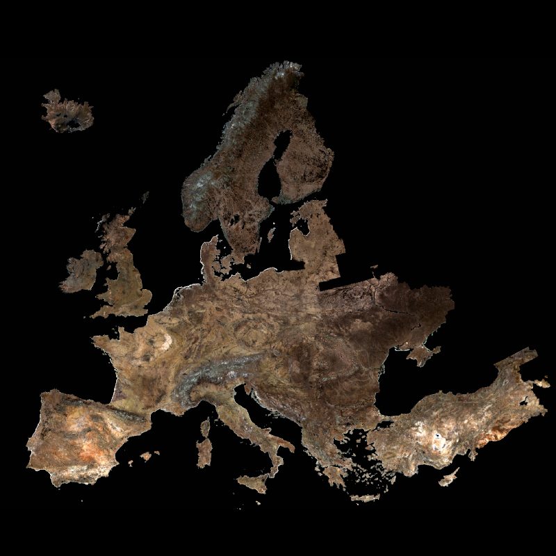
| The SoilSuite contains a collection of different image data products that provide information about the spectral and statistical properties of European soils and other bare surfaces such as rocks. It is created using DLR's Soil Composite Mapping Processor (ScMAP), which utilises the Sentinel-2 data archive. SCMaP is a specialised processing chain for detecting and analysing bare soils/surfaces on a large (continental) scale. Bare surface and soil pixels are selected using a combined NDVI and NBR index (PVIR2) that optimises the exclusion of photosynthetically active and non-active vegetation. The index is calculated and applied for each individual pixel. All SoilSuite products are calculated based on the available Sentinel-2 scenes recorded between January 2018 and December 2022 in Europe. The data package excludes all scenes with a cloud cover of > 80 % and a sun elevation of < 20°. The spectral composite products are calculated from the mean value after extensive removal of clouds, haze and snow effects at both scene and pixel level. The spectral data products are available at a pixel size of 20 m and contain 10 Sentinel-2 bands (B02, B03, B04, B05, B06, B07, B08, B08a, B11, B12). The SoilSuite comprises: (a) “Bare Surface Reflectance Composite – Mean” that provides the spectral properties of soils that vary due to different soil organic carbon (SOC) content, soil moisture and soil minerology. This product is often used for spectral and digital soil mapping approaches, (b) “Bare Surface Reflectance Composite - Standard deviation” informing about the spectral dynamic of bare surfaces and soils, (c) “Bare Surface Reflectance Composite – 95% Confidence” contains information about the reliability of the spectral information due to the number of valid observations per pixel, (d) “Bare Surface Statistics Product” provides the number of bare soil occurrences over the total number of valid observations (Band 1), the number of bare soil occurrences (Band 2) and the total number of valid observations (Band 3), (e) “Mask” is a product that aggregates simple landcover classes that occur during the time period between 2018 - 2022 (Sentinel-2). The three-class Mask contains bare surface occurrences (1), permanent vegetation (2) and other surfaces such as water bodies, urban areas, roads (3). Additionally, the SoilSuite provides (f) “Reflectance Composite – Mean” that represents the mean reflectance of all valid Sentinel-2 observations between 2018 – 2022 including vegetation, bare and other surfaces, and (g) “Reflectance Composite – Standard deviation”, which contains the standard deviation per band for all valid Sentinel-2 observations between 2018 – 2022. | ||
 |
||
| Suggested Data Citation | ||
| SoilSuite (2024): Sentinel-2 5-year (2018-2022) composites at European Scale, German Aerospace Center (DLR) https://doi.org/10.15489/qkud8cudg596 | ||
| Coverage | ||
| Geographic Boundaries | ||
| North: | 73.1027728° | |
| West: | -29.1771809° | |
| East: | 49.4217946° | |
| South: | 32.376872° | |
| Time Period | ||
| Start date: | 2018-03-01 | |
| End date: | 2022-12-31 | |
| More Information | ||
| Keywords: | DLR, EOC, Land, SCMaP, Soil, Sentinel-2, Europe, Temporal Composites, Soil Coverage, Soil Composite Mapping Processor, Reflectance Composite, Surface Reflectance Composite, Bare Soil Coverage, Bare Soil Frequency, opendata | |
| Contact: | geoservice@dlr.de | |
| Access / Use Restriction: | License | |
| Data Use Guidelines | Creative Commons BY 4.0 | |
| Links | ||
| Mission / Project Information | ||
| DOI (of Dataset) | https://doi.org/10.15489/qkud8cudg596 Digital Object Identifier |
|
| Data Description | https://download.geoservice.dlr.de/SOILSUITE/files/EUROPE_5Y/000_Data_Overview/SoilSuite_Data_Description_Europe_V1.pdf SoilSuite Europe Data Description (pdf) |
|
| Scientific Publication | https://doi.org/10.1016/j.rse.2017.11.004 Rogge, D., Bauer, A, Zeidler, J., Müller, A., Esch, T. and Heiden, U. (2018). Building an exposed soil composite processor (SCMaP) for mapping spatial and temporal characteristics of soils with Landsat imagery (1984-2014). Remote Sensing of Environment, 205, 1-17. ISSN 0034-4257. |
|
| Scientific Publication | https://doi.org/10.3390/rs14184526 Heiden, U., d’Angelo, P., Schwind, P., Karlshöfer, P., Müller, R., Zepp, S., Wiesmeier, M., & Reinartz, P. (2022). Soil Reflectance Composites—Improved Thresholding and Performance Evaluation. Remote Sensing, 14(18), 4526. |
|
| Scientific Publication | https://doi.org/10.1016/j.geoderma.2025.117340 Karlshoefer, P., d’Angelo, P., Eberle, J., & Heiden, U. (2025). Evaluation framework for the generation of continental bare surface reflectance composites. Geoderma, 459. |
|
| EOC Geoservice Dataset Landing Page | https://geoservice.dlr.de/web/datasets/soilsuite_eur_5y Dataset Landing Page |
|
| Product Search / Ordering | ||
| Product Catalogue (STAC): SoilSuite | https://geoservice.dlr.de/eoc/ogc/stac/v1/collections/S2-soilsuite-europe-2018-2022-P5Y SoilSuite – Sentinel-2 – Europe, 5 year composite |
|
| Data Visualization Service | ||
| EOC Geoservice Map Context (eoc:soilsuite:5y:eur) | https://geoservice.dlr.de/web/maps/eoc:soilsuite:5y:eur EOC Geoservice Map Context |
|
| SoilSuite – Mask, Europe | https://geoservice.dlr.de/eoc/land/wms? SOILSUITE_MASK_EUR_P5Y |
|
| SoilSuite – Reflectance Composite – Standard deviation, Europe | https://geoservice.dlr.de/eoc/land/wms? SOILSUITE_MREF-STD_EUR_P5Y |
|
| SoilSuite – Reflectance Composite, Mean – Europe | https://geoservice.dlr.de/eoc/land/wms? SOILSUITE_MREF_EUR_P5Y |
|
| SoilSuite – Bare surface count, Europe | https://geoservice.dlr.de/eoc/land/wms? SOILSUITE_SFREQ-BSC_EUR_P5Y |
|
| SoilSuite – Bare surface frequency, Europe | https://geoservice.dlr.de/eoc/land/wms? SOILSUITE_SFREQ-BSF_EUR_P5Y |
|
| SoilSuite – Valid pixel count, Europe | https://geoservice.dlr.de/eoc/land/wms? SOILSUITE_SFREQ-VPC_EUR_P5Y |
|
| SoilSuite – Bare Surface Reflectance Composite – 95% Confidence, Europe | https://geoservice.dlr.de/eoc/land/wms? SOILSUITE_SRC-CI95_EUR_P5Y |
|
| SoilSuite – Bare Surface Reflectance Composite - Standard deviation, Europe | https://geoservice.dlr.de/eoc/land/wms? SOILSUITE_SRC-STD_EUR_P5Y |
|
| SoilSuite – Bare Surface Reflectance Composite – Mean, Europe | https://geoservice.dlr.de/eoc/land/wms? SOILSUITE_SRC_EUR_P5Y |
|
| Downloading Data | ||
| HTTP Download (SoilSuite) | https://download.geoservice.dlr.de/SOILSUITE/files/EUROPE_5Y/ HTTP Download |
|