DLR
EOC
Land
SCMaP
Soil
Sentinel-2
Temporal Composites
Soil Coverage
Soil Composite Mapping Processor
Reflectance Composite
Surface Reflectance Composite
Bare Soil Coverage
Bare Soil Frequency
The SoilSuite contains a collection of different image data products that provide information about the spectral and statistical properties of European soils and other bare surfaces such as rocks. It is created using DLR's Soil Composite Mapping Processor (ScMAP), which utilises the Sentinel-2 data archive.
SCMaP is a specialised processing chain for detecting and analysing bare soils/surfaces on a large (continental) scale. Bare surface and soil pixels are selected using a combined NDVI and NBR index (PVIR2) that optimises the exclusion of photosynthetically active and non-active vegetation. The index is calculated and applied for each individual pixel. All SoilSuite products are calculated based on the available Sentinel-2 scenes recorded between January 2018 and December 2022 in Europe. The data package excludes all scenes with a cloud cover of > 80 % and a sun elevation of < 20 degrees. The spectral composite products are calculated from the mean value after extensive removal of clouds, haze and snow effects at both scene and pixel level. The spectral data products are available at a pixel size of 20 m and contain 10 Sentinel-2 bands (B02, B03, B04, B05, B06, B07, B08, B08a, B11, B12).
The SoilSuite comprises:
"Mask" is a product that aggregates simple landcover classes that occur during the time period between 2018 - 2022 (Sentinel-2). The three-class Mask contains bare surface occurrences (1), permanent vegetation (2) and other surfaces such as water bodies, urban areas, roads (3).
"Bare Surface Reflectance Composite - Mean" that provides the spectral properties of soils that vary due to different soil organic carbon (SOC) content, soil moisture and soil minerology. This product is often used for spectral and digital soil mapping approaches
"Bare Surface Reflectance Composite - Standard deviation" informing about the spectral dynamic of bare surfaces and soils
"Bare Surface Reflectance Composite - 95% Confidence" contains information about the reliability of the spectral information due to the number of valid observations per pixel
"Bare Surface Frequency Product" provides the number of bare soil occurrences over the total number of valid observations (Band 1)
"Bare Surface Count Product" provides the number of bare soil occurrences (Band 2).
"Valid Pixel Count Product" provides the total number of valid observations (Band 3)
"Reflectance Composite - Mean" represents the mean reflectance of all valid Sentinel-2 observations between 2018 - 2022 including vegetation, bare and other surfaces
"Reflectance Composite - Standard deviation", which contains the standard deviation per band for all valid Sentinel-2 observations between 2018 - 2022.
References:
- Rogge, D., Bauer, A, Zeidler, J., Müller, A., Esch, T. and Heiden, U. (2018). Building an exposed soil composite processor (SCMaP) for mapping spatial and temporal characteristics of soils with Landsat imagery (1984-2014). Remote Sensing of Environment, 205, 1-17. ISSN 0034-4257 DOI: 10.3390/rs14184526
- Heiden, U., d’Angelo, P., Schwind, P., Karlshöfer, P., Müller, R., Zepp, S., Wiesmeier, M., & Reinartz, P. (2022). Soil Reflectance Composites—Improved Thresholding and Performance Evaluation. Remote Sensing, 14(18), 4526. DOI: 10.1016/j.rse.2017.11.004
- Karlshoefer, P., d’Angelo, P., Eberle, J., & Heiden, U. (2025). Evaluation framework for the generation of continental bare surface reflectance composites. Geoderma, 459. DOI: 10.1016/j.geoderma.2025.117340
Contacts:
- Uta Heiden (Producer, Processor) DLR/EOC Imaging Spectroscopy
- Pablo d'Angelo (Producer, Processor) DLR/EOC Photogrammetry and Image Analysis
Properties:
Items:
The MASK product aggregates simple landcover classes that occur during the time period between 2018 - 2022 (Sentinel-2). The three-class Mask contains: (1) Bare surface occurrences, (2) Permanent vegetation, (3) Other surfaces (e.g. water bodies, urban areas, roads).
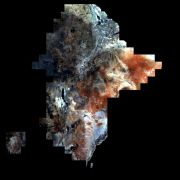
The Bare Surface Reflectance Composite (Mean) contains reflectance values scaled between 0 and 10.000. It represents the mean reflectance of all Sentinel-2 bare surface occurrences between 2018 - 2022 excluding urban areas, water bodies, clouds, haze, cloud shadows and snow. This product is one of the main inputs for spectral as well as digital soil mapping approaches.
The Bare Surface Reflectance Composite (Std Dev) contains the standard deviation of all Sentinel-2 bare surface reflectance values occuring between 2018 - 2022. It is scaled between 0 and 10.000 for each band and excludes urban areas, water bodies, clouds, haze, cloud shadows and snow. This product quantifies e.g. the spectral dynamic of soils, which might differ according to their physical and chemical properties and thus, can be taken as an additional characteristic of the soil.
The Bare Surface Reflectance Composite (95% Confidence) contains the half-width of the 95% confidence interval (CI) of the Bare Surface Reflectance Composite that contains Sentinel-2 reflectance values of all bare surface occurrences collected between 2018 - 2022.
The Bare Surface Frequency is scaled between 0 and 1 and quantifies the ratio of bare surface occurrences over the total number of valid Sentinel-2 observations in the observed time period between 2018 - 2022.
The Bare Surface Count is defined as the number of occurrences detected as bare surface between 2018 - 2022. It is not normalized to the total number of valid Sentinel-2 observations. The value reveals the dependence of the pixel position across the ground track that can lead to nearly double observations in overlapping orbits.
This Valid Pixel Count contains the total number of valid Sentinel-2 observations in the time period between 2018 - 2022 excluding cloud, haze, cloud shadow, snow, etc..
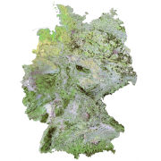
The Reflectance Composte (Mean) contains reflectance values per band, scaled between 0 and 10.000. It represents the mean reflectance of all valid Sentinel-2 observations between 2018 - 2022. Valid observations include vegetation, bare and other surfaces and exclude clouds, haze, cloud shadows and snow.
The Reflectance Composite (Std Dev) contains the standard deviation per band for all valid Sentinel-2 observations between 2018 - 2022, scaled from 0 to 10.000. The valid observations include vegetation, bare surfaces and other surfaces and it excludes clouds, haze, cloud shadows and snow. The product quantifies the spectral dynamic of all landcover types occurring in the images. As an example, it shows a higher standard deviation in agricultural areas compared to natural grasslands.
Related Datasets:
SoilSuite – Sentinel-2 – Africa, 4 year composite (2018-2021)
2025-06-03
Soil Composite Mapping Processor (SCMaP) Products (30 years)
2018-11-17
Soil Composite Mapping Processor (SCMaP) Products (5 years)
2018-11-17
