Introduction
The SRTM X-SAR digital elevation models (DEMs) have been generated
from
X-band synthetic aperture radar (SAR) data acquired during the Shuttle
Radar Topography Mission (SRTM) in the year 2000. SRTM mission was
conducted
jointly between the German Aerospace Center (DLR), the Italian Space
Agency (ASI), the US National Aeronautics and Space Administration
(NASA) and the US Jet Propulsion Laboratory (JPL). From February 11 to
22, 2000, two
interferometric radar systems onboard the space shuttle Endeavor
acquired data with the objective to generate a global high resolution
digital elevation model. The American radar system, operating in C-band
(SIR-C),
was complemented by the German-Italian X-SAR, a higher resolution
X-band synthetic aperture radar (SAR) system. At this time, the SRTM
DEMs were the first elevation dataset with worldwide uniform quality.
The SRTM X-SAR DEM (1 arcsec) offered here for download were processed
from data of the German-Italian X-SAR instrument.
Overview of the SRTM X-SAR product specification
- The SRTM X-SAR DEM represents a Digital Surface Model (DSM):
That means it does not represent the bare earth surface, but the top
layer of earth's surface as seen from space. Canopies or man-made
objects can therefore also contribute to height values of individual
cells.
- The 'SRTM X-SAR 10° Regional Mosaics' release is the most recent reprocessed and repacked version of the original product:
The original 'SRTM X-SAR 15’ Tiles', first released in 2001, have been
merged to 10° tiles and converted from DTED to GeoTIFF-format in order
to provide this interesting dataset in an easy-to-use and state-of
the-art format. For more
information on the release history of the SRTM X-SAR DEM see chapter
Download the SRTM X-SAR 10° Regional Mosaics.
DEM Accuracy
One pixel of the SRTM X-SAR DEM has a resolution of 1 x 1 arcsecond on the
ground. The metric correspondence of this value is latitude dependent and roughly equals 30m x 30m. Elevation
values are provided as integer numbers at 1 m intervals.
No data voids are a result of the original processing logic
applied and a NoData value of -32767 is attributed to them. As normally those are
single or few neighboring pixels, which can easily be interpolated
employing standard geographic image processing software.
The
DEMs have not been edited with respect to coastlines and water bodies.
Therefore, coastlines may not be well defined and water bodies may not
be perfectly flat.
The product specification concerning accuracy of the SRTM X-SAR 25m DEM products is defined as:
- Absolute horizontal precision: CE90 +/- 20m (circular error at 90% confidence level)
- Relative horizontal precision: CE90 +/- 15m (circular error at 90% confidence level)
- Absolute vertical precision: VE90 +/- 16m (vertical error at 90% confidence level)
- Relative vertical precision: VE90 +/- 6m (vertical error at 90% confidence level)
DEM Coverage
The orbit of the SRTM mission was chosen in a way that the US SIR-C instrument could cover all land mass between
57° S und 60° N at least once. Unlike the C-band SAR, the X-band SAR
had no steering capacity and hence couldn't operate in ScanSAR mode.
Also, at the benefit of a higher resolution, the swath of the X-SAR was
with 50 km considerably narrower than the 225 km wide ScanSAR swath of the
SIR-C instrument. This is why there are inevitable gaps between the
individual ground-tracks of the X-SAR. Those gaps narrow down with
latitude increase. Other gaps are a result of shuttle motion
caused by orbit maneuvers, during which the radar instruments were not
able to record. In total the X-SAR covered during the mission an area
of about 112 million square kilometers of which 64 million square kilometers were land
surface. That corresponds with roughly 43 percent of the global land
surface.
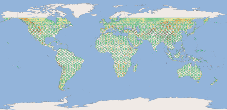
Global land coverage of the SRTM X-SAR DEM
Height Error Map
Besides the elevation
information, a confidence level (height error map, HEM) has also been
calculated for each pixel. It has been estimated statistically by taking
neighboring pixels into account and is primarily a reflection of the
stability of the phase values and the baseline (i.e. the relative position
of the two antennas). The HEM thus describes accuracy relative to
neighborhood. Reference data is required to determine absolute
precision.
Product file structure of the 'SRTM X-SAR 10° Regional Mosaics' Release
The SRTM X-SAR 10° Regional Mosaics are delivered in a flat .zip
format without internal subfolders. Each .zip file contains the
following layers:
- Digital elevation model (DEM)
- Height error map (HEM)
- Quicklook (png image)
- Quicklook (kmz overlay)
- Readme document; containing a.o. license information
Data type of the 'SRTM X-SAR 10° Regional Mosaics' Release
DEM and HEM files are of file format GeoTIFF. Compression is applied at individual file level, not at zip level.
- Type: signed integer 16 bit (Int16)
- Compression: Deflate with predictor 2
- Tiled
- 2/4/8/16/32 overviews with blocksize 256 x 256
- Projection: Geographic (Lat/Long), WGS84 (EPSG: 4326)
Download the SRTM X-SAR 10° Regional Mosaics
SRTM X-SAR DEM Releases
Since the first release of the SRTM X-SAR DEM in the year 2001, DLR
EOC has continuously put data curation efforts into this
valuable dataset in order to keep it accessible in a state-of-the art and user friendly way.
The most recent release of the SRTM X-SAR DEM is the SRTM X-SAR 10° x
10° Regional Mosaics in GeoTIFF format. But also
the original DTED format dataset computed during the initial SRTM X-SAR
processing
remain preserved in the German Satellite Data Archive (D-SDA). In
addition, EOC Geoservice offers a
series of global WMS/WCS layer products derived from the original SRTM
X-SAR
DEM. All instances of the SRTM X-SAR DEM originate from
the initial SRTM X-SAR 15’ Tiles dataset and therefore represent
identical cell data values.
- SRTM X-SAR 15’ Tiles:
The original DEM product packages generated during the mission, each containing the DEM and
HEM covering an area of 15’x15’ provided in *DTED format. For access to this historic dataset preserved at D-SDA, please contact the EOC Geoservice Team.
- SRTM X-SAR 10° Regional Mosaics:
Zip-archives containing 10°x10° mosaics of the elevation data (DEM) and
the height error map (HEM) together with a quicklook and a footprint
and browse image in kmz format. The filename specifies the bottom left
coordinate of the 10°x10° mosaic. Single tiles or lists of tiles can be
downloaded directly from the EOC Download service SRTM X-SAR page. For
detailed information on the download procedure see chapter 'Download
Instructions for the SRTM X-SAR 10° Regional Mosaics' below.
- SRTM X-SAR Global Mosaics: Global layers (DEM, HEM, shaded relief) derived from the SRTM X-SAR DEM dataset and offered via WMS and WCS interfaces of the EOC Geoservice.
Download Instructions for the 'SRTM X-SAR 10° Regional Mosaics'
EOC download service offers three different download options:
- HTTP map-based interface: Select and download using your web-browser by marking individual tiles on a map
- Bulk download a list of tiles: Download using a download manager
- HTTP browse: Use your web-browser to directly browse through the directory structure and download tiles
HTTP map-based Interface
This download option is recommended for users who wish to download
some selected regional products and prefer the usage of a map driven
interface for the selection of the products. Visit the
EOC Download service SRTM X-SAR page. The
page will appear with basic information about the SRTM X-SAR mission on
the left and the map interface (showing a color coded version of the
SRTM X-SAR DEM) with the polygon outline for each individual DEM tile on
the right. You can alter the map layer(s) using the
icon in the top right corner above the map canvas. Zoom to your region
of interest and select the desired products by a left-click onto the
respective tile. Name and volume of the
product now appears in a list on the left side.
Alternatively you can also draw a search rectangle (CTRL C and open
search area with the mouse) in order to download
the products for a larger region of interest. Selected products can
be downloaded one by one by clicking on the download icon (arrow down)
next to each item. Depending on the browser you use, products may
eventually be saved to your default download folder without further
notification.
Bulk download a list of tiles
Mark the tiles you want to
download in a way as described in the paragraph above. Select the 'List'
icon to save the download list to an ASCII text file (with an absolute
pathname for each file per line), or to an XML-like metalink file by
selecting the metalink icon.
The ASCII file list can then be fed to a command line client
(e.g. wget or cURL), or a download manager (e.g. aria2). The following
code examples illustrate the usage of those command line tools.
Supposed you have saved the list to the name
‘SRTM_XSAR-url-list.txt’ to your current working directory and the
download directory will be the current working directory as well: then
the wget command would be the following one-liner:
Built a wget command according to the following:
wget -i SRTM_XSAR-url-list.txt
Built a cURL command according to the following:
curl $(printf ' -O %s' $(<SRTM_XSAR-url-list.txt))
or:
xargs -a SRTM_XSAR-url-list.txt -L1 curl -0
Built an aria2 command according to the following:
aria2c -i SRTM_XSAR-url-list.txt
The metalink XML file can be fed to a download manager tool (e.g.
aria2). Suppose you have saved the metalink to the file name
‘SRTM_XSAR.meta4’ in your current working directory, then the command line
for aria2 would be:
aria2c -M SRTM_XSAR.meta4
HTTP Browse
The files can be also accessed via HTTPS by entering the following URL path into your web browser:
https://download.geoservice.dlr.de/SRTM_XSAR/files/
Conditions of Access and Use
The use of the SRTM X-SAR DEMs is governed by the following conditions of use. When accessing and using
the data the user accepts the conditions of use detailed below.
The SRTM X-SAR DEMs are intended primarily for scientific purposes.
Redistribution of the original SRTM XSAR DEMs is not permitted, neither
for commercial nor for non-commercial purposes. No further restrictions,
except those contained herein, are being imposed on the use of the DEMs
or derived products.
The SRTM X-SAR DEM products have been
generated to the highest possible standards of accuracy using
state-of-the-art technology. However, the products are provided as is.
No warranty of any kind, whether explicit or implied is given.
Furthermore, since the products are provided free-of-charge, DLR shall
not be liable
for any damage arising out of the SRTM X-SAR products’ use. The user is
responsible for observing that no
damage is caused to anyone or anything by his use of the SRTM X-SAR
products. By obtaining the SRTM XSAR products, the user therefore agrees
to hold the German Aerospace Center (DLR) harmless from and
against any and all claims which might arise by himself or any third
party from the use of the SRTM X-SAR
products.
For all derived products based on the SRTM X-SAR DEM products and for all publications including these data
or derived products, using the following copyright information is mandatory: ©DLR/ASI 2000.