DLR
EOC
Forest
Canopy Cover Loss
Disturbance
Sentinel-2
Landsat
Multispectral
Germany
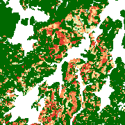
This raster dataset shows forest canopy cover loss (FCCL) in Germany at a monthly resolution from September 2017 to October 2025. It is similar to the product developed in Thonfeld et al. (2022) but was fully reprocessed and updated to reveal the most recent forest disturbance dynamics (Thonfeld et al. 2026).
The combination of Sentinel-2A/B and Landsat-8/9 data allows for a high temporal resolution while the pixel size of the product is 10 m. The results are clipped to the stocked area 2018 mapped by the Thünen-Institute (Langner et al. 2022, https://doi.org/10.3220/DATA20221205151218). The dataset contains predominantly larger canopy openings resulting from different drivers but also larger clusters of standing deadwood. FCCL can result from abiotic (e.g. wind, fire, drought, hail) drivers, biotic (e.g. insects, funghi) drivers or a combination of both as well as from sanitary and salvage logging and planned harvest.
References:
- Thonfeld, F., Kacic, P., Holzwarth, S., Wegler, M., Asam, S., Kuenzer, C., 2026. Forest canopy cover loss dynamics in Germany between 2017 and 2024 - Revealing regional differences. International Journal of Applied Earth Observation and Geoinformation 146, 105157. DOI: 10.1016/j.jag.2026.105157
- Thonfeld, F., Gessner, U., Holzwarth, S., Kriese, J., da Ponte, E., Huth, J., Kuenzer, C., 2022. A First Assessment of Canopy Cover Loss in Germany’s Forests after the 2018-2020 Drought Years. Remote Sensing 14, 562. DOI: 10.3390/rs14030562
- Langner, N., Oehmichen, K., Henning, L., Blickensdörfer, L., Riedel, T., 2022. Bestockte Holzbodenkarte 2018. DOI: 10.3220/DATA20221205151218
Items:
The Forest Canopy Cover Loss (FCCL) shows the forest canopy cover loss in Germany in monthly resolution between September 2017 and September 2024 at 10 m spatial resolution.
The Forest Canopy Cover Loss (FCCL) monthly result mask shows a decision tree-based classification of the FCCL layer into intact forest, (consistent) FCCL, and temporal changes in coniferous, deciduous, and unclassified forests.
The Forest Canopy Cover Loss (FCCL) monthly observed changes displays how often an observation exceeded a threshold. It is also counted in pixels not labeled as FCCL.
The Forest Canopy Cover Loss (FCCL) Percentage of Gaps shows the percentage of gaps (i.e., an observation not exceeding a threshold) in pixels labeled as FCCL.
Related Datasets:

Forest Canopy Cover Loss - Germany - Monthly, Administrative Level
2025-06-06
Tree Canopy Cover Loss - Germany, 2018-2021
2022-08-11
