DLR
EOC
Forest
vegetation
Canopy Cover Loss
Drought
Disturbance Index
Landsat-8
Sentinel-2
time-series
Germany
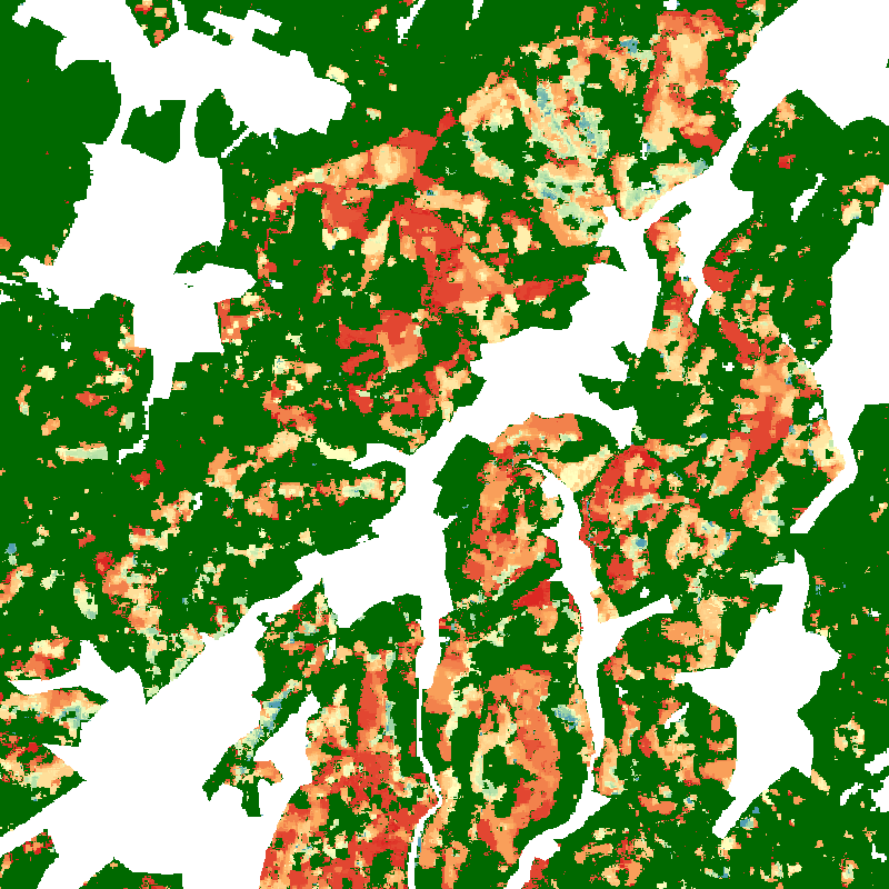
This repository contains tree canopy cover loss information between January 2018 and April 2021 for Germany at monthly resolution. The analysis is based on monthly image composites of the disturbance index (DI) derived from Sentinel-2 and Landsat-8 time series. Deviations from a 2017 reference median DI image exceeding a threshold are recorded as losses. The method used to derive this product as well as the mapping results are described in detail in Thonfeld et al. (2022). The map depicts areas of natural disturbances (windthrow, fire, droughts, insect infestation) as well as sanitation and salvage logging, and regular forest harvest without explicitly differentiating these drivers.
References:
- Thonfeld, F., Gessner, U., Holzwarth, S., Kriese, J., da Ponte, E., Huth, J., Kuenzer, C., 2022. A First Assessment of Canopy Cover Loss in Germany’s Forests after the 2018-2020 Drought Years. Remote Sensing 14, 562. DOI: 10.3390/rs14030562
- Healey, S., Cohen, W., Zhiqiang, Y., Krankina, O., 2005. Comparison of Tasseled Cap-based Landsat data structures for use in forest disturbance detection. Remote Sensing of Environment 97, 301-310. DOI: 10.1016/j.rse.2005.05.009
Items:
The products depicts per-pixel tree canopy cover loss at 10 m spatial resolution from January 2018 till April 2021.
Title: CSW
Endpoint: https://geoservice.dlr.de/catalogue/srv/eng/csw
Record ID: 3a5f8f67-aede-4325-aee6-83330ea046f1
Record: GetRecord (XML)
This is a vector data set showing per-district statistics of all forests tree canopy cover loss in ha in Germany between January 2018 and April 2021 on annual basis and as sum of all years. Statistics are available for coniferous and deciduous forests as well as across both forest types.
Title: CSW
Endpoint: https://geoservice.dlr.de/catalogue/srv/eng/csw
Record ID: 281e0d18-0ae0-449f-88ee-acab8626a77f
Record: GetRecord (XML)
This is a vector data set showing per-district statistics of all forests tree canopy cover loss in % in Germany between January 2018 and April 2021 on annual basis and as sum of all years. Statistics are available for coniferous and deciduous forests as well as across both forest types.
Title: CSW
Endpoint: https://geoservice.dlr.de/catalogue/srv/eng/csw
Record ID: 281e0d18-0ae0-449f-88ee-acab8626a77f
Record: GetRecord (XML)
This is a vector data set showing per-district statistics of coniferous tree canopy cover loss in ha in Germany between January 2018 and April 2021 on annual basis and as sum of all years. Statistics are available for coniferous and deciduous forests as well as across both forest types.
Title: CSW
Endpoint: https://geoservice.dlr.de/catalogue/srv/eng/csw
Record ID: 281e0d18-0ae0-449f-88ee-acab8626a77f
Record: GetRecord (XML)
This is a vector data set showing per-district statistics of coniferous tree canopy cover loss in % in Germany between January 2018 and April 2021 on annual basis and as sum of all years. Statistics are available for coniferous and deciduous forests as well as across both forest types.
Title: CSW
Endpoint: https://geoservice.dlr.de/catalogue/srv/eng/csw
Record ID: 281e0d18-0ae0-449f-88ee-acab8626a77f
Record: GetRecord (XML)
This is a vector data set showing per-district statistics of deciduous tree canopy cover loss in ha in Germany between January 2018 and April 2021 on annual basis and as sum of all years. Statistics are available for coniferous and deciduous forests as well as across both forest types.
Title: CSW
Endpoint: https://geoservice.dlr.de/catalogue/srv/eng/csw
Record ID: 281e0d18-0ae0-449f-88ee-acab8626a77f
Record: GetRecord (XML)
This is a vector data set showing per-district statistics of deciduous tree canopy cover loss in % in Germany between January 2018 and April 2021 on annual basis and as sum of all years. Statistics are available for coniferous and deciduous forests as well as across both forest types.
Title: CSW
Endpoint: https://geoservice.dlr.de/catalogue/srv/eng/csw
Record ID: 281e0d18-0ae0-449f-88ee-acab8626a77f
Record: GetRecord (XML)
Related Datasets:

Forest Canopy Cover Loss - Germany - Monthly, 10m
2025-05-20