DLR
EOC
DFD
TanDEM-X
PolarDEM
Cryosphere
Polar
Antarctica
topography
DEM
editing
coastline
The TanDEM-X PolarDEM is a project developed by the German Remote Sensing Data Center (DFD) at the German Aerospace Center (DLR) within the activities of the TanDEM-X mission. It is a framework for the provision of derivatives of the global Digital Elevation Model (DEM) of the TanDEM-X mission for Polar Regions.
The current version of the global TanDEM-X DEM represents an unedited surface model that still contains noisy or void DEM values, some data gaps and a compilation of several acquisition campaigns performed at different times. The derivatives currently include the edited DEM product described below and will be supplemented with single year coverages and penetration bias corrected DEMs in the future.
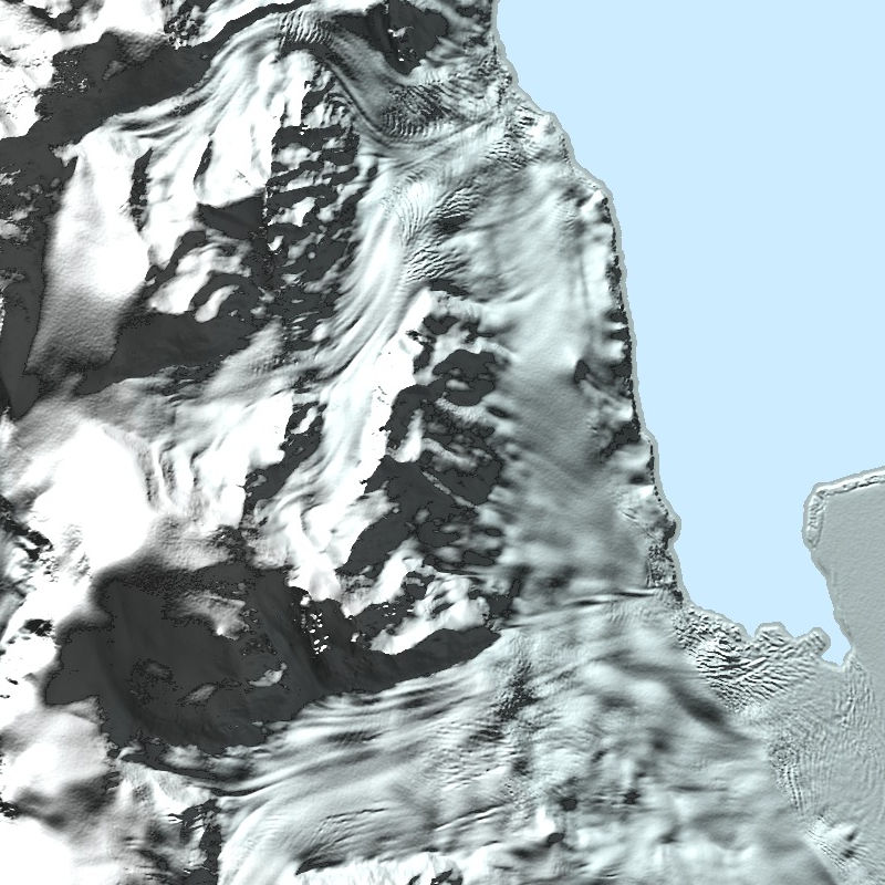
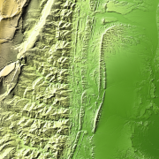
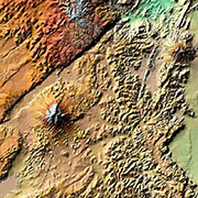
TanDEM-X PolarDEM 90m of Antarctica: This is a gap-free and edited version of the TanDEM-X 90m DEM. The TanDEM-X PolarDEM 90m of Antarctica is provided in Antarctic Polar Stereographic projection (EPSG:3031) with a pixel spacing of 90 meters. The DEM elevation values represent the ellipsoidal heights relative to the WGS84 ellipsoid. The majority of the data were acquired between April 2013 to September 2014. The TanDEM-X PolarDEM 90m of Antarctica is split into 4 tiles. TanDEM-X PolarDEM High Resolution Coastline of Antarctica: This is a by-product to the DEM-editing process of the TanDEM-X PolarDEM of Antarctica in the original 12 m representation. It is provided as one polygon in shapefile-format. Every point of this polygon is given in Antarctic Polar Stereographic projection (EPSG:3031) with varying point distances with a minimum span of 10 meters.
References:
- Wessel, B., Huber, M., Wohlfart, C., Bertram, A., Osterkamp, N., Marschalk, U., Gruber, A., Reuß, F., Abdullahi, S., Georg, I., and Roth, A., TanDEM-X PolarDEM 90m of Antarctica - Generation and error characterization, The Cryosphere Discuss. [preprint], https://doi.org/10.5194/tc-2021-19, in review, 2021. DOI: 10.5194/tc-2021-19
Items:
This layer is a gap-free and edited version of the TanDEM-X 90m DEM. The TanDEM-X PolarDEM 90m of Antarctica is provided in Antarctic Polar Stereographic projection (EPSG:3031) with a pixel spacing of 90 meters. The DEM elevation values represent the ellipsoidal heights relative to the WGS84 ellipsoid. The majority of the data were acquired between April 2013 to September 2014. The TanDEM-X PolarDEM 90m of Antarctica is split into 4 tiles.
A hillshade generated from the TanDEM-X PolarDEM 90m elevation layer. This shading represents a combination slope and oblique shading.
A hillshade generated from the TanDEM-X PolarDEM 90m elevation layer. This multidirectional shading combines of hillshading illuminated from 225 deg, 270 deg, 315 deg, and 360 deg azimuth.
Coastline derived from the TanDEM-X PolarDEM elevation layer.
Related Datasets:
TanDEM-X 30m Edited DEM (EDEM)
2023-11-15

TanDEM-X 30m DEM Change Maps (DCM)
2023-11-15
TanDEM-X 90m DEM
2023-11-15