DLR
EOC
TanDEM-X
DEM
Digital Elevation Model
TDM 30m DCM
global
InSAR
TSX-1
land
DEM Change Maps
Change
Change Detection
TanDEM-X 4D
The TanDEM-X DEM Change Maps are a project developed by the Institute Remote Sensing Technology (IMF) at the German Aerospace Center (DLR) within the activities of the TanDEM-X Mission.
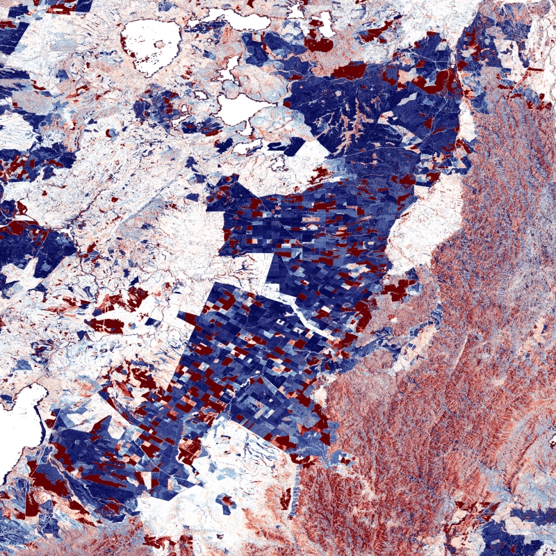
Between 2016 and 2022, the TanDEM-X mission acquired an additional complete coverage of the Earth's landmass to deliver a temporally independent coverage within a well-defined time span. These new acquisitions not only provide more up-to-date elevation information, but also a great dataset to show the changes that have occurred during the years separating this new coverage from the coverages acquired to generate the TanDEM-X global DEM (between 2011 and 2014). This product - the TanDEM-X DEM Change Maps - is available in 30m posting and show the changes between the edited first global TanDEM-X DEM (TanDEM-X 30m Edited DEM) and the newly acquired time-tagged DEM scenes. In order to keep a unique timestamp, two change maps are available per tile: one with the change to the oldest pixel in the new dataset - the first DEM change, and another with the change to the newest pixel of the new dataset - the last DEM change. The two maps differ only when there are multiple coverages.
Users must be aware that a given elevation change measured in the DEM change maps corresponds to a topographic change with respect to TanDEM-X 30m EDEM, but cannot be associated with a corresponding physical height change of the same magnitude. This is due to the fact that the global TanDEM-X DEM reflects an averaged elevation derived from the combination of different images, acquired over a period of several years but also because the radar waves penetrates differently in the surface depending on the attributes of the land cover. This is especially important over vegetated and snow-covered regions.
References:
- M. Lachaise, C. González, P. Rizzoli, B. Schweiβhelm and M. Zink, "The New Tandem-X DEM Change Maps Product," IGARSS 2022 - 2022 IEEE International Geoscience and Remote Sensing Symposium, Kuala Lumpur, Malaysia, 2022, pp. 5432-5435. DOI: 10.1109/IGARSS46834.2022.9883612
- TD-GS-PS-0216 TanDEM-X 30m DEM Change Maps Product Description, M. Lachaise, B. Schweißhelm., Oct 2023 1.0 Link
Items:
The DEM Change Maps (DCM) values represent the change in meter between the new acquisitions from 2016 til 2022 and the edited TanDEM-X DEM. There are two DCMs, one for the earliest change and on for the latest change. When only one new acquisition is available, the earliest and the latest change layers are equal.
The DEM Change Maps (DCM) values represent the change in meter between the new acquisitions from 2016 til 2022 and the edited TanDEM-X DEM. There are two DCMs, one for the earliest change and on for the latest change. When only one new acquisition is available, the earliest and the latest change layers are equal.
The DATE layers give the acquisition dates for every pixel.
The DATE layers give the acquisition dates for every pixel.
The Change Indication Masks (CIM) provide an indication about the reliability of the Change depicted in the DCMs.
The Change Indication Masks (CIM) provide an indication about the reliability of the Change depicted in the DCMs.
The Height Accuracy Indication (HAI) values are an approximation of the Height Errors of the DCMs under the assumptions that the errors are normally distributed
The Height Accuracy Indication (HAI) values are an approximation of the Height Errors of the DCMs under the assumptions that the errors are normally distributed
Related Datasets:
TanDEM-X 30m Edited DEM (EDEM)
2023-11-15
TanDEM-X 90m DEM
2023-11-15

TanDEM-X PolarDEM 90m of Antarctica
2023-11-15