| Alpine Glacier Crevasses - Stubai, Oetztal, Grossglockner, Ortler, Piz Palue, 0.2m |
2019 |
2022 |
| DESIS - Hyperspectral Images - Global |
2018 |
ongoing |
| DBFSAR - RGI/GTC/INF |
2018 |
ongoing |
| ELK - Global Emission Inventory - Aviation Sector, 2019 |
2019 |
2019 |
| ELK - Global Emission Inventory - Energy-for-Transport Sector, 2019 |
2019 |
2019 |
| ELK - Global Emission Inventory - Land Transport Sector, 2019 |
2019 |
2019 |
| ELK - Global Emission Inventory - Shipping Sector, 2019 |
2019 |
2019 |
| E-SAR - RGI/GTC/INF |
1999 |
2009 |
| F-SAR - RGI/GTC/INF |
2010 |
ongoing |
| EnMAP HSI - Level 0 / Quicklook Images - Global |
2022 |
ongoing |
| fCover - Sentinel-2 - Netherlands, 2016 |
2016 |
2016 |
| Firebird MSC – Level 0 Multispectral Images |
2014 |
ongoing |
| Forest Canopy Cover Loss (FCCL) - Germany - Monthly, 10m |
2017 |
2024 |
| Forest Canopy Cover Loss - Germany - Monthly, Administrative Level |
2017 |
2024 |
| Global WaterPack - MODIS - Daily |
2003 |
2024 |
| Global WaterPack - MODIS - Monthly |
2003 |
2024 |
| Global WaterPack - MODIS - Yearly |
2003 |
2024 |
| HySpex - Level 2 Hyperspectral Images - Bohemian Forest |
2013 |
ongoing |
| IceLines - Sentinel-1 - Antarctica |
2014 |
ongoing |
| Land Cover DE - Sentinel-2 - Germany, 2015 |
2015 |
2017 |
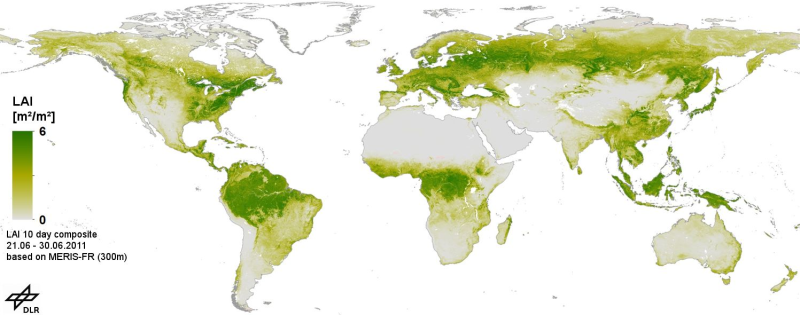
| MERIS - Gap Free Leaf Area Index (LAI) - Global |
2003 |
2011 |
| Noise - Road Traffic Lden (AI Prediction) - Germany, 2017 |
2017 |
2017 |
| Noise - Road Traffic Lden (2002/49/EC) - Germany, 2017 |
2017 |
2017 |
| Polar Monitor - Ice sheet drainage basins - Antarctica, 2010-2021 |
2010 |
2021 |
| SCMaP - Landsat - Germany, 1984-2014 |
1984 |
2014 |
| Sentinel-1 - NRB Level-1C - Global |
2014 |
ongoing |
| Sentinel-2 MSI - Level 2A (MAJA Tiles) - Germany |
2015 |
ongoing |
| Sentinel-2 MSI - Level 3A (MAJA/WASP Tiles) - Germany |
2015 |
ongoing |
| Sentinel-2 - Vegetation Index (NDVI) - Germany, 2015 |
2015 |
2017 |
| Sentinel-5P TROPOMI – Formaldehyde (HCHO), Level 3 – Global |
2018 |
ongoing |
| Sentinel-5P TROPOMI – Cloud Optical Thickness (COT), Level 3 – Global |
2018 |
ongoing |
| Sentinel-5P TROPOMI – Ozone (O3), Level 3 – Global |
2018 |
ongoing |
| Sentinel-5P TROPOMI – Cloud Fraction (CF), Level 3 – Global |
2018 |
ongoing |
| Sentinel-5P TROPOMI – Sulfur Dioxide (SO2), Level 3 – Global |
2018 |
ongoing |
| Sentinel-5P TROPOMI – Cloud-Top Height (CTH), Level 3 – Global |
2018 |
ongoing |
| SoilSuite – Sentinel-2 – Europe, 5 year composite (2018-2022) |
2018 |
2022 |
| TanDEM-X High-Resolution Coastline - Global, 10m |
2010 |
2015 |
| TanDEM-X - Digital Elevation Model (DEM) - Global, 90m |
2010 |
2015 |
| TanDEM-X - PolarDEM - Antarctica, 90m |
2013 |
2017 |
| Tree Canopy Cover Loss Monthly - Landsat-8/Sentinel-2 - Germany, 2018-2021 |
2018 |
2021 |
| Tree Species - Sentinel-1/2 - Germany, 2022 |
2021 |
2023 |
| UrMo Digital - Traffic Area Map (TAM) - Brunswick, Germany |
2019 |
2020 |
| World Settlement Footprint (WSF) 2015 v2 - Landsat-8/Sentinel-1 - Global |
2012 |
2019 |
| World Settlement Footprint (WSF) 2019 - Sentinel-1/2 - Global |
2019 |
2019 |
| World Settlement Footprint (WSF) 3D - Material Stock - Global, 90m |
2012 |
2019 |